The Map That Mistakes Distance for Access
Rural map distance can make a nearby service look reachable. Learn to read route continuity, crossings and connections before deciding how accessible it is.
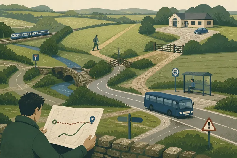
A clinic, library or village hall can sit just beyond a field and still take an awkward journey to reach. Rural map distance is a poor stand-in for access: a straight line shows where a place is, not whether there is a usable route to it. The useful question is not simply “How far away?” but “By what route, with what connections, and for whom?”
That distinction matters when comparing places, deciding whether a service is practically nearby, or asking a council to review a route. Start by sorting the journey according to the way you expect to make it. The same destination can be accessible by car and difficult on foot, or reachable by bus on one day and effectively cut off on another.
Is the destination close by car?
If you are driving, begin with the road network rather than the map’s ruler. A short straight line may be interrupted by a river, railway, steep slope, private land or a road that has no crossing point nearby. The actual route may have to travel towards a bridge, then double back towards the destination.
Trace the journey from a realistic starting point, such as the centre of the village or the road where a visitor would park. Look for junctions, narrow lanes, gates, one-way arrangements and places where the route depends on a road that may be difficult to use in poor weather. A route can be short in distance yet awkward in practice if it requires a difficult turn or has no safe place to pull in.
Next, distinguish the road network from the last part of the trip. A map may lead to a car park or roadside entrance, while the actual destination lies beyond a long drive, locked gate or path. If someone has limited mobility, carries equipment or is travelling with a young child, that final stretch can matter more than the distance between village and destination.
Driving is the best fit when the road route is continuous, the arrival point is clear, and parking or a suitable drop-off point is available. It is a weaker fit when the journey depends on a narrow or seasonal access road, or when a driver must leave the vehicle far from the entrance. Do not let a neat route line conceal the conditions at either end.
Can you walk the route continuously?
If you are walking, ask whether the route forms a continuous public path, not whether a footpath symbol appears somewhere nearby. Rights of way can end at a boundary, cross a road without a convenient crossing, or meet another path that does not lead where the map suggests. A short gap between path segments may be a substantial obstacle on the ground.
Check for the kind of connection that makes a walk usable: a pavement, verge, signed public footpath, pedestrian bridge or crossing with enough visibility. Then look at what the route asks a person to do at its most exposed point. A path may be perfectly clear across a field but require walking along a fast road to reach it.
Surface and gradient are separate questions from continuity. A muddy track, loose gravel, steep incline or narrow stile can change who can use a route, particularly for someone with a wheelchair, walking frame, pushchair or bicycle. A map generally cannot settle those details; local rights-of-way information, recent photographs and a direct enquiry to the relevant council or land manager can help clarify them.
Walking fits when the route is open to the public, connected from start to finish and suitable for the person making the journey. If one of those conditions is missing, a nearby destination may not be a realistic walk. The distinction is like a chain: a single missing link can make the whole route unusable, however close its ends appear.
Does public transport reach the place you need?
If you rely on a bus or community transport, distance to a stop is only one part of the journey. You also need a service that runs at a useful time, a connection between the stop and the destination, and a return journey that works after the appointment or activity. A stop beside the destination is no help if the bus does not serve it when you need to travel.
Check the timetable for the day of travel rather than assuming that weekday and weekend services are alike. Look for the direction of travel, any request-stop arrangements, the time allowed for a connection, and what happens if the first leg is delayed. Where a service must be booked in advance, find out how bookings are made and whether the operating days fit the purpose of the trip.
Then inspect the interchange. A bus may leave you on the far side of a main road, at a stop without a footway, or in a place where the onward path is unclear. The map may show two services meeting at a village, but the practical connection can still involve a long wait or an unsafe crossing.
Public transport is a good fit when the schedule aligns with the reason for travel and the transfer points are usable. It is a poor fit when the return depends on an infrequent service, the last bus leaves too early, or a connection requires an uncertain wait. For journeys that matter, confirm service details with the operator or local transport provider before setting out; timetables and arrangements can change.
Are you comparing places rather than planning one trip?
If you are choosing where to live, assessing a proposed service location or describing access for a community discussion, avoid ranking places by straight-line distance alone. Compare the route people would actually use, the modes available and the conditions that affect different users. A single “nearest” label can hide a long walk, an impractical bus timetable or a road journey that requires a wide detour.
Keep the comparison legible. For each starting point, note the destination, likely mode, route continuity and any connection that could make the journey difficult. It is often more useful to distinguish “reachable by car”, “walkable on a continuous public route” and “served by public transport at relevant times” than to collapse them into one claim about access.
Say you are comparing two hamlets for a proposed weekly advice session. One is closer to the hall as the crow flies, but the walk crosses a busy road without a nearby crossing and the bus arrives after the session begins. The other is farther away on the map, yet has a continuous lane-side footway and a bus that arrives beforehand. The second may be more accessible for people who do not drive, while the first may remain easier for someone making a direct car journey. The comparison changes with the intended users and mode.
For a public discussion, describe the specific break in the journey rather than saying only that a place is “too far”. Identify the missing crossing, disconnected path, inconvenient interchange or unsuitable timetable. That gives the service provider, parish council or transport authority something concrete to examine, without pretending that one route suits everyone.
What should you check before calling a place accessible?
What does a straight-line distance actually tell you?
It indicates how far apart two points are on a map, but not the route between them. Use it as a rough location cue, not as evidence that a journey is convenient or possible.
How can you tell whether a footpath connects to the destination?
Trace the public route from the starting point to the entrance and inspect every junction and road crossing. Check rights-of-way information where the map leaves the route’s public status or continuity unclear.
What matters most when comparing bus access?
Check operating days and times, the walk from stop to destination, and whether the return journey works. A nearby stop does not make a service accessible if its timetable misses the purpose of the trip.
Which map should you trust for the final decision?
Use a map to identify possible routes, then check current operator information, local path records and conditions on the ground. No single map layer normally answers questions about timetable, surface, access rights and the needs of each traveller.
When does a map need a second source?
Use mapping to form a route, not to settle every practical detail. Different map layers can show roads, rights of way, bus stops and terrain, but those layers may be incomplete or updated at different times. A marked path does not necessarily tell you its present surface; a stop symbol does not tell you whether a bus runs on the day you need it.
For roads and public transport, check current information from the relevant highway authority or operator. For footpaths, consult the local authority’s rights-of-way map and ask about unclear access. If a journey involves land that may be private, a gate, a restricted crossing or a route that appears closed, do not assume that a line on a map grants permission to pass.
Where access depends on disability adjustments or a specific mobility requirement, ask the service or venue about the entrance, internal route and drop-off arrangements rather than inferring them from the surrounding map. The right answer depends on the information supplied by the operator or land manager and, where relevant, local rules. That is a practical boundary, not a reason to abandon the map altogether.
What is the useful measure of rural map distance?
Rural map distance is most useful as the beginning of an access question. It helps locate a service and compare approximate proximity; route continuity, crossings, timetables and the final approach decide whether people can actually reach it. Keep those questions separate, then make the judgement for the journey and traveller in front of you.
When sharing a route or discussing a service, state the mode and the point where the journey becomes difficult. A clear note such as “the stop is close, but the return bus leaves before the session ends” is more useful than an unqualified claim that the venue is nearby. The map can show where the problem begins; a good description tells others what needs attention.